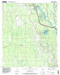
1998 Map of Hickory
USGS Topo · Published 1999About this map
The low-lying wetlands of eastern St. Tammany Parish are defined here by the winding channels of the West Pearl River and the Bogue Chitto River. This 1998 survey illustrates the complex hydrology of the river basin, featuring numerous sloughs and bayous including Maple Slough, Ernest Slough, and Lacombe Bayou. Within the Bogue Chitto National Wildlife Refuge, the landscape is divided into named landforms such as Holmes Island and Pats Hammock.
Find a feature on this map
51 named features on this map. Tap any name to fly to it.
Don’t see what you’re looking for? This feature index may not catch every label — zoom into the map to look around manually.
Map Details
Editions of this 1998 Hickory Map
This is the sole edition of this map. No revisions or reprints were ever made.
Other maps of this area

1914 · Nicholson
USGS Topo · 1:62,500

1921 · Nicholson
USGS Topo · 1:62,500

1935 · Slidell
USGS Topo · 1:62,500

1939 · Slidell
USGS Topo · 1:62,500

1941 · Honey Island
USGS Topo · 1:31,680

1942 · Talisheek
USGS Topo · 1:31,680

1942 · Walkiah Bluff
USGS Topo · 1:31,680

1950 · Haaswood
USGS Topo · 1:31,680

1950 · Slidell
USGS Topo · 1:62,500

1953 · Mobile
USGS Topo · 1:250,000