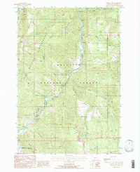
1988 Map of Hidden Lake
USGS Topo · Published 1988About this map
The Lee Metcalf Wilderness and Gallatin National Forest dominate this mountain landscape during the late 1980s. The topography is defined by the Gallatin River corridor, which flows north through the center of the sheet, flanked by the Spanish Peaks and Levinski Ridge. Historically significant crossing points like Jack Smith Bridge and Highs Bridge provided essential access across the river for travelers and forest managers.
Find a feature on this map
32 named features on this map. Tap any name to fly to it.
Don’t see what you’re looking for? This feature index may not catch every label — zoom into the map to look around manually.
Map Details
Editions of this 1988 Hidden Lake Map
2 editions found
Other maps of this area

1888 · Three Forks
USGS Topo · 1:250,000

1894 · Three Forks
USGS Topo · 1:250,000

1895 · Three Forks
USGS Topo · 1:250,000

1947 · Bozeman
USGS Topo · 1:250,000

1948 · Bozeman
USGS Topo · 1:250,000

1950 · Spanish Peaks
USGS Topo · 1:62,500

1950 · Sphinx Mountain
USGS Topo · 1:62,500

1955 · Bozeman
USGS Topo · 1:250,000

1955 · Garnet Mountain
USGS Topo · 1:62,500

1955 · Crown Butte
USGS Topo · 1:62,500