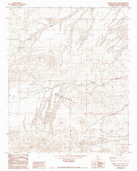
1982 Map of Hidden Valley East
USGS Topo · Published 1993About this map
The Cady Mountains dominate this high-desert landscape in San Bernardino County, where the terrain is defined by complex drainage systems and arid basins. Based on field checks from 1976 and aerial photography from the mid-1970s, this document records the intricate network of alluvial fans and dry watercourses that shape the Mojave Desert. The vast expanse of Hidden Valley is bisected by the Hidden Valley Wash, which drains toward the northeast. Throughout the mountains, the presence of various 4wd tracks indicates a landscape navigated by off-road utility and exploration rather than established towns or paved infrastructure. To the north, the terrain transitions toward the broad Baxter Wash, illustrating the characteristic desert geomorphology of the region before significant modern development or drainage changes were observed during later photoinspections.
Find a feature on this map
5 named features on this map. Tap any name to fly to it.
Don’t see what you’re looking for? This feature index may not catch every label — zoom into the map to look around manually.
Map Details
Editions of this 1982 Hidden Valley East Map
2 editions found
Other maps of this area

1933 · Avawatz Mountains
USGS Topo · 1:250,000

1947 · Trona
USGS Topo · 1:250,000

1948 · Trona
USGS Topo · 1:250,000

1948 · Cave Mountain
USGS Topo · 1:62,500

1951 · Cave Mountain
USGS Topo · 1:62,500

1953 · San Bernardino
USGS Topo · 1:250,000

1953 · Trona
USGS Topo · 1:250,000

1955 · Cady Mountains
USGS Topo · 1:62,500

1955 · Broadwell Lake
USGS Topo · 1:62,500

1956 · San Bernardino
USGS Topo · 1:250,000