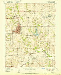
1951 Map of Higginsville
USGS Topo · Published 1951About this map
The Confederate Home and the Fairground anchor the western edge of Higginsville, a regional hub defined by its convergence of rail and industry in the early 1950s. The landscape is marked by the operations of the Gulf Mobile and Ohio and Missouri Pacific railroads, which serviced the numerous coal mines and mine dumps that dotted the surrounding townships. The rural character of Dover and Davis townships is evidenced by a dense network of country schools, including the Peacock Sch, Republican Sch, and Jennings Sch.
Find a feature on this map
47 named features on this map. Tap any name to fly to it.
Don’t see what you’re looking for? This feature index may not catch every label — zoom into the map to look around manually.
Map Details
Editions of this 1951 Higginsville Map
This is the sole edition of this map. No revisions or reprints were ever made.
Other maps of this area

1885 · Warrensburg
USGS Topo · 1:125,000

1887 · Warrensburg
USGS Topo · 1:125,000

1889 · Lexington
USGS Topo · 1:125,000

1894 · Warrensburg
USGS Topo · 1:125,000

1917 · Knobnoster
USGS Topo · 1:62,500

1947 · Jefferson City
USGS Topo · 1:250,000

1949 · Mayview
USGS Topo · 1:24,000

1949 · Lexington East
USGS Topo · 1:24,000

1950 · Lexington East
USGS Topo · 1:24,000

1950 · Mayview
USGS Topo · 1:24,000