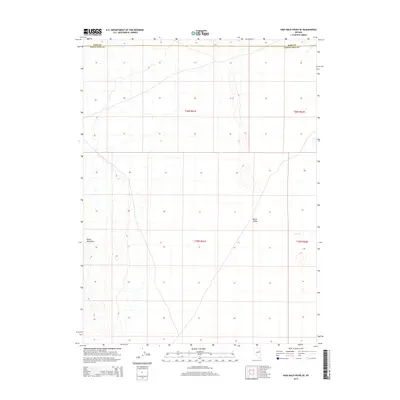
2014 Map of High Bald Peaks SE
USGS Topo · Published 2014About this map
Butte Valley dominates this high-elevation Great Basin landscape along the border of Elko and White Pine counties. This 2014 survey captures the vast, open character of the region where the basin floor meets the western slopes of the Butte Mountains. Within this arid environment, the ephemeral drainage of Paris Cr emerges, tracing a path through the eastern reaches of the valley. The map details the Township and Range grid system across t26n r61e and surrounding sections, providing a precise spatial reference for the ranching lands and public tracts that define this portion of northeastern Nevada. The absence of modern infrastructure underscores the remote, undeveloped nature of the terrain during the early 21st century.
Find a feature on this map
8 named features on this map. Tap any name to fly to it.
Don’t see what you’re looking for? This feature index may not catch every label — zoom into the map to look around manually.
Map Details
Editions of this 2014 High Bald Peaks SE Map
This is the sole edition of this map. No revisions or reprints were ever made.
Other maps of this area

1955 · Elko
USGS Topo · 1:250,000

1956 · Ely
USGS Topo · 1:250,000

1958 · Elko
USGS Topo · 1:250,000

1959 · Ely
USGS Topo · 1:250,000

1962 · Elko
USGS Topo · 1:250,000

1963 · Ely
USGS Topo · 1:250,000

1965 · Elko
USGS Topo · 1:250,000
1982 · Ninemile Well
USGS Topo · 1:24,000
1982 · Exchequer Spring
USGS Topo · 1:24,000
1982 · Ninemile Well NW
USGS Topo · 1:24,000