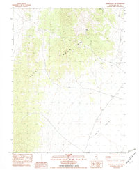
1982 Map of Ninemile Well NW
USGS Topo · Published 1982About this map
Butte Mountains form a central backbone across this 1982 provisional survey, separating the broad basins of Long Valley to the west and Butte Valley to the east. This high desert landscape in White Pine County is defined by its sparse water sources and topographic isolation, with named points such as Pony Springs and Willow Spring marking critical hydrology in an otherwise arid range. The terrain suggests a history of transient occupation and livestock grazing, further evidenced by a single Ruin and several unnamed trails or unimproved roads that navigate the complex contour of the mountains. The map preserves the exact locations of several benchmarks, including BM 1911.8, providing a precise record of the regional elevation and surveying network during the early 1980s. A quiet Seep on the western slopes further highlights the importance of localized water features for both early inhabitants and later ranching efforts in this part of Nevada.
Find a feature on this map
12 named features on this map. Tap any name to fly to it.
Don’t see what you’re looking for? This feature index may not catch every label — zoom into the map to look around manually.
Map Details
Editions of this 1982 Ninemile Well NW Map
This is the sole edition of this map. No revisions or reprints were ever made.
Other maps of this area

1955 · Elko
USGS Topo · 1:250,000

1956 · Ely
USGS Topo · 1:250,000

1958 · Elko
USGS Topo · 1:250,000

1959 · Ely
USGS Topo · 1:250,000

1962 · Elko
USGS Topo · 1:250,000

1963 · Ely
USGS Topo · 1:250,000

1965 · Elko
USGS Topo · 1:250,000
1968 · Ruby Lake SE
USGS Topo · 1:24,000

1982 · Ninemile Well
USGS Topo · 1:24,000
1982 · Junction Well
USGS Topo · 1:24,000