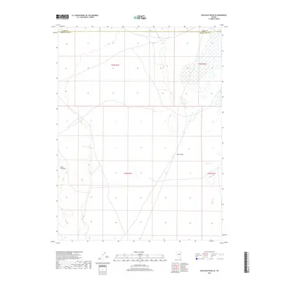
2018 Map of High Bald Peaks SE
USGS Topo · Published 2018About this map
Butte Valley dominates the central portion of this 2018 survey, reflecting the characteristic basin-and-range geography of northeastern Nevada. The Butte Mountains rise to the west, providing a significant vertical contrast to the broad alluvial plains that define the township boundaries. Water is notably sparse in this high-desert environment, with Paris Cr serving as one of the few named drainage features in the region. The map captures the boundary between Elko and White Pine counties, showing a landscape primarily shaped by section lines and remote access roads. This topographic study is a clear representation of the vast open spaces in the Great Basin, where land use is largely defined by the Public Land Survey System rather than dense settlement.
Find a feature on this map
8 named features on this map. Tap any name to fly to it.
Don’t see what you’re looking for? This feature index may not catch every label — zoom into the map to look around manually.
Map Details
Editions of this 2018 High Bald Peaks SE Map
This is the sole edition of this map. No revisions or reprints were ever made.
Other maps of this area

1955 · Elko
USGS Topo · 1:250,000

1956 · Ely
USGS Topo · 1:250,000

1958 · Elko
USGS Topo · 1:250,000

1959 · Ely
USGS Topo · 1:250,000

1962 · Elko
USGS Topo · 1:250,000

1963 · Ely
USGS Topo · 1:250,000

1965 · Elko
USGS Topo · 1:250,000
1982 · Ninemile Well
USGS Topo · 1:24,000
1982 · Exchequer Spring
USGS Topo · 1:24,000
1982 · Ninemile Well NW
USGS Topo · 1:24,000