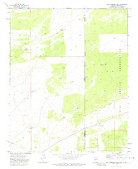
1971 Map of High Lonesome Well
USGS Topo · Published 1975About this map
The Zuni Indian Reservation defines the eastern and southern portions of this landscape, where the high desert terrain crosses the state line from Arizona into New Mexico. This 1970s survey illustrates a ranching and navigational infrastructure focused on water access and boundary marking. Points such as High Lonesome Well and East Well No 11 are central to the geography of the area, providing necessary water sources for livestock in a territory marked by scattered corrals and isolated tanks.
Find a feature on this map
22 named features on this map. Tap any name to fly to it.
Don’t see what you’re looking for? This feature index may not catch every label — zoom into the map to look around manually.
Map Details
Editions of this 1971 High Lonesome Well Map
This is the sole edition of this map. No revisions or reprints were ever made.
Other maps of this area

1886 · St Johns
USGS Topo · 1:250,000

1886 · Wingate
USGS Topo · 1:250,000

1886 · Fort Defiance
USGS Topo · 1:250,000

1892 · Fort Defiance
USGS Topo · 1:250,000

1892 · St Johns
USGS Topo · 1:250,000

1892 · Wingate
USGS Topo · 1:250,000

1954 · Saint Johns
USGS Topo · 1:250,000

1954 · Gallup
USGS Topo · 1:250,000

1957 · Saint Johns
USGS Topo · 1:250,000

1958 · Gallup
USGS Topo · 1:250,000