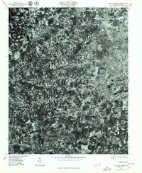
1977 Map of High Point West
USGS Topo · Published 1979About this map
The industrial corridor between High Point and Thomasville is captured in this 1977 orthophotoquad, showing the dense residential and commercial expansion of the late 1970s. This specialized map format uses rectified aerial imagery to reveal the exact physical footprint of the region's development during a period of significant growth. To the north, the community of Oakview transitions into a more fragmented landscape of cleared fields and woodlots. The natural drainage of the Piedmont is visible through the winding courses of Abbotts Creek and the headwaters of the Uwharrie River, which provide a sharp visual contrast to the rigid grid of the urban centers. For local historians and researchers, the photographic detail provides a precise record of neighborhood layouts and industrial sites before decades of subsequent infill changed the character of these North Carolina manufacturing hubs.
Find a feature on this map
5 named features on this map. Tap any name to fly to it.
Don’t see what you’re looking for? This feature index may not catch every label — zoom into the map to look around manually.
Map Details
Editions of this 1977 High Point West Map
This is the sole edition of this map. No revisions or reprints were ever made.
Other maps of this area

1949 · Eller
USGS Topo · 1:24,000

1949 · High Point West
USGS Topo · 1:24,000

1950 · High Point East
USGS Topo · 1:24,000

1950 · Lexington East
USGS Topo · 1:24,000

1950 · Winston-Salem East
USGS Topo · 1:24,000

1951 · Winston-Salem East
USGS Topo · 1:24,000

1951 · Lexington East
USGS Topo · 1:24,000

1951 · High Point East
USGS Topo · 1:24,000

1951 · Guilford
USGS Topo · 1:24,000

1951 · Fair Grove
USGS Topo · 1:24,000