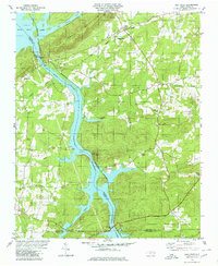
1980 Map of High Rock
USGS Topo · Published 1980About this map
High Rock Mountain towers over the northern bend of the Yadkin River, anchoring a landscape defined by the expansive waters of High Rock Lake and the Tuckertown Reservoir. This 1980 survey captures a region where agriculture and recreation meet the southern reaches of the Uwharrie National Forest. Small communities like Jackson Hill and Newsom are mapped alongside numerous country sanctuaries, including Lick Creek Ch and Taylor Grove Ch.
Find a feature on this map
41 named features on this map. Tap any name to fly to it.
Don’t see what you’re looking for? This feature index may not catch every label — zoom into the map to look around manually.
Map Details
Editions of this 1980 High Rock Map
2 editions found
Other maps of this area

1949 · High Rock
USGS Topo · 1:24,000

1949 · Denton NW
USGS Topo · 1:24,000

1953 · Charlotte
USGS Topo · 1:250,000

1954 · Charlotte
USGS Topo · 1:250,000

1957 · Mount Pleasant
USGS Topo · 1:62,500

1957 · Albemarle
USGS Topo · 1:62,500

1957 · Denton
USGS Topo · 1:62,500

1960 · Charlotte
USGS Topo · 1:250,000

1962 · Charlotte
USGS Topo · 1:250,000

1962 · Southmont
USGS Topo · 1:24,000