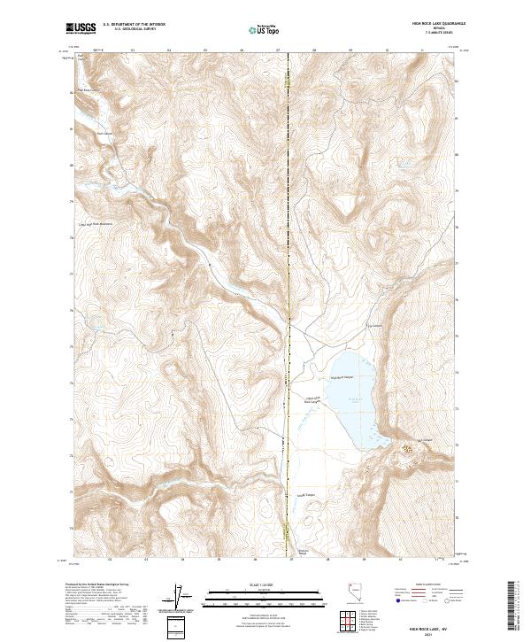
2021 Map of High Rock Lake
USGS Topo · Published 2021About this map
High Rock Lake sits at the heart of a complex basin where the Washoe and Humboldt county lines meet. This landscape is defined by the dramatic descent of High Rock Canyon and Little High Rock Canyon, features that historically dictated travel and drainage patterns across northwestern Nevada. The map details a hydrographic network including High Rock Cr, Fly Cr, and the seasonal Franco Reservoir, which are vital in this arid terrain. Topographical landmarks like the Little High Rock Mountains and the Division Range frame the basin, while smaller water sources such as Powers Spring and Laxaque Spring highlight the locations of life-sustaining water points essential for early land use and stock management in the region.
Find a feature on this map
22 named features on this map. Tap any name to fly to it.
Don’t see what you’re looking for? This feature index may not catch every label — zoom into the map to look around manually.
Map Details
Editions of this 2021 High Rock Lake Map
This is the sole edition of this map. No revisions or reprints were ever made.
Other maps of this area

1889 · Long Valley
USGS Topo · 1:250,000

1954 · Vya
USGS Topo · 1:250,000

1958 · Vya
USGS Topo · 1:250,000

1962 · Vya
USGS Topo · 1:250,000

1972 · Mud Meadow
USGS Topo · 1:24,000

1972 · Mahogany Mtn
USGS Topo · 1:24,000

1972 · Soldier Meadow
USGS Topo · 1:24,000

1972 · High Rock Lake
USGS Topo · 1:24,000
1972 · Yellow Hills East
USGS Topo · 1:24,000
1972 · Yellow Hills West
USGS Topo · 1:24,000