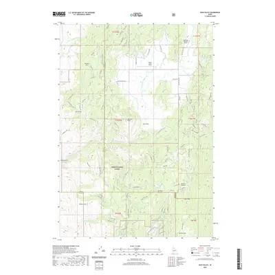
2020 Map of High Valley
USGS Topo · Published 2020About this map
High Valley characterizes this high-altitude landscape of Gem County, Idaho, where remote mountain drainage systems shape the local geography. The map traces the upper reaches of Kennedy Cr, a seasonal watercourse that cuts through the upland terrain. This area remains sparsely developed, with the natural hydrography and elevation contours illustrating the rugged nature of the Boise National Forest surroundings. The layout of the High Valley settlement reflects a legacy of timber and ranching activities typical of this region of Idaho, where access was historically dictated by the flow of creeks and the rise of the surrounding ridges.
Find a feature on this map
2 named features on this map. Tap any name to fly to it.
Don’t see what you’re looking for? This feature index may not catch every label — zoom into the map to look around manually.
Map Details
Editions of this 2020 High Valley Map
This is the sole edition of this map. No revisions or reprints were ever made.
Other maps of this area

1894 · Squaw Creek
USGS Topo · 1:125,000

1953 · Smiths Ferry
USGS Topo · 1:62,500

1953 · Banks
USGS Topo · 1:62,500

1955 · Baker
USGS Topo · 1:250,000

1959 · Baker
USGS Topo · 1:250,000

1970 · Dodson Pass
USGS Topo · 1:24,000
1970 · Ola
USGS Topo · 1:24,000
1970 · Webb Creek
USGS Topo · 1:24,000

1980 · Weiser
USGS Topo · 1:100,000
1985 · Banks
USGS Topo · 1:24,000