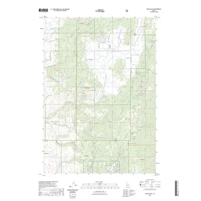
2023 Map of High Valley
USGS Topo · Published 2023About this map
High Valley sits at the intersection of Gem, Valley, and Boise Counties, defined by a high-elevation landscape of ridges and drainages within the Boise National Forest. The map documents a complex network of forest roads and historic routes, including the Ola-Smiths Ferry and its predecessor, the Old Ola-Smiths Ferry, which navigate the passage over Ola Summit. This area is characterized by significant topographic features such as Fletcher Butte and Dry Buck Mtn, alongside specialized aviation infrastructure like the High Valley Airport and Hidden Lakes Airport.
Find a feature on this map
32 named features on this map. Tap any name to fly to it.
Don’t see what you’re looking for? This feature index may not catch every label — zoom into the map to look around manually.
Map Details
Editions of this 2023 High Valley Map
This is the sole edition of this map. No revisions or reprints were ever made.
Other maps of this area

1894 · Squaw Creek
USGS Topo · 1:125,000

1953 · Smiths Ferry
USGS Topo · 1:62,500

1953 · Banks
USGS Topo · 1:62,500

1955 · Baker
USGS Topo · 1:250,000

1959 · Baker
USGS Topo · 1:250,000

1970 · Dodson Pass
USGS Topo · 1:24,000
1970 · Ola
USGS Topo · 1:24,000
1970 · Webb Creek
USGS Topo · 1:24,000

1980 · Weiser
USGS Topo · 1:100,000
1985 · Banks
USGS Topo · 1:24,000