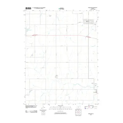
2009 Map of Highland
USGS Topo · Published 2009About this map
Highland serves as the primary hub in this corner of Northeast Kansas, surrounded by a rolling drainage network defined by the Wolf River and its numerous tributaries. The landscape is etched with the transition between traditional rural farming communities and modern infrastructure, featuring active landing strips like Sommers Airport and Rush Airport. While Highland occupies the northeastern heights, the smaller settlements of Leona and Severance are positioned along the southern drainage basins, providing clear evidence of historic town planning near water sources and transportation corridors. Local genealogy is well-documented through sites such as Highland Cemetery and Oak Hill Cemetery. The western edge of the quadrangle is marked by the Brown County State Lake, illustrating the regional importance of water management and recreation in this part of Doniphan County.
Find a feature on this map
35 named features on this map. Tap any name to fly to it.
Don’t see what you’re looking for? This feature index may not catch every label — zoom into the map to look around manually.
Map Details
Editions of this 2009 Highland Map
This is the sole edition of this map. No revisions or reprints were ever made.
Other maps of this area

1885 · Atchison
USGS Topo · 1:125,000

1888 · Atchison
USGS Topo · 1:125,000

1893 · Atchison
USGS Topo · 1:125,000

1926 · Atchison
USGS Topo · 1:62,500

1926 · Oregon
USGS Topo · 1:62,500

1950 · Kansas City
USGS Topo · 1:250,000

1954 · Kansas City
USGS Topo · 1:250,000

1956 · Kansas City
USGS Topo · 1:250,000
1959 · Oregon
USGS Topo · 1:24,000
1959 · White Cloud
USGS Topo · 1:24,000