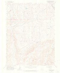
1960 Map of Highland Peak
USGS Topo · Published 1967About this map
White River National Forest defines the high-altitude landscape of this area, where the peaks of Highland Peak and Eagle Mtn rise above a network of waterways and early recreation sites. In the southern portion of the quadrangle, a string of roadside destinations including Maroon Creek Campground 1 and Maroon Creek Campground 2 sit along the banks of Maroon Creek. The drainage patterns are clearly defined by the East Fork Brush Creek and West Fork Brush Creek, which converge as they flow north toward the Roaring Fork River. At the northeastern corner, the D & R G W railroad line skirts the river valley near Cozy Point. This era shows a transition in land use, balancing the infrastructure of the Wildcat Reservoir and Marolt Reservoir with the primitive access of numerous Pack Trails and Jeep Trails that crisscross the mountain slopes.
Find a feature on this map
26 named features on this map. Tap any name to fly to it.
Don’t see what you’re looking for? This feature index may not catch every label — zoom into the map to look around manually.
Map Details
Editions of this 1960 Highland Peak Map
4 editions found
Other maps of this area

1893 · Aspen
USGS Topo · 1:62,500

1895 · Aspen
USGS Topo · 1:62,500

1909 · Mount Jackson
USGS Topo · 1:125,000

1911 · Mount Jackson
USGS Topo · 1:125,000

1957 · Leadville
USGS Topo · 1:250,000

1959 · Leadville
USGS Topo · 1:250,000

1960 · Leadville
USGS Topo · 1:250,000

1960 · Highland Peak
USGS Topo · 1:24,000

1960 · Maroon Bells
USGS Topo · 1:24,000
1960 · Hayden Peak
USGS Topo · 1:24,000