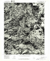
1977 Map of Highland Springs
USGS Topo · Published 1979About this map
Adobe Creek winds through the complex drainage patterns of the California landscape in this late-1970s orthophoto. Produced by the U.S. Geological Survey from aerial photography taken in June 1977, this sheet provides a photographic record of the terrain rather than a traditional line-drawn topographic map. The imagery reveals the stark contrast between the intricate, undeveloped ridge systems and the regulated patterns of agricultural land use visible on the eastern edge of the quadrangle. By focusing on the path of Adobe Creek, researchers can observe the natural riparian corridors and how they interact with the surrounding topography in Lake County before significant modern development altered the land's surface. The orthophoto format preserves the visual texture of the vegetation and soil, offering a clear view of the geological structure and land management practices of the era.
Find a feature on this map
1 named feature on this map. Tap any name to fly to it.
Don’t see what you’re looking for? This feature index may not catch every label — zoom into the map to look around manually.
Map Details
Editions of this 1977 Highland Springs Map
2 editions found
Other maps of this area

1920 · Ukiah
USGS Topo · 1:62,500

1921 · Kelseyville
USGS Topo · 1:62,500

1938 · Lakeport
USGS Topo · 1:62,500

1938 · Hopland
USGS Topo · 1:62,500

1943 · Kelseyville
USGS Topo · 1:62,500

1943 · Hopland
USGS Topo · 1:62,500

1944 · Ukiah
USGS Topo · 1:62,500

1944 · Hopland
USGS Topo · 1:62,500

1947 · Santa Rosa
USGS Topo · 1:250,000

1949 · Santa Rosa
USGS Topo · 1:250,000