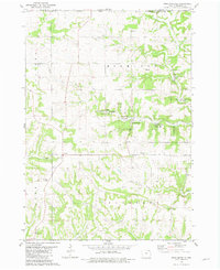
1981 Map of Highlandville
USGS Topo · Published 1982About this map
Highlandville and the surrounding townships of Highland, Canoe, and Pleasant define this corner of Winneshiek County in the early 1980s. The landscape is deeply carved by the waters of South Bear Creek and Paint Creek, creating a complex network of ridges and valleys that dictate the placement of rural homesteads and winding roads. A legacy of early settlement is visible through numerous family and community landmarks, such as Egge Cem and Seegmiller Cem, alongside quiet local gathering places like Highland Ch and Big Canoe Ch.
Find a feature on this map
29 named features on this map. Tap any name to fly to it.
Don’t see what you’re looking for? This feature index may not catch every label — zoom into the map to look around manually.
Map Details
Editions of this 1981 Highlandville Map
This is the sole edition of this map. No revisions or reprints were ever made.
Other maps of this area

1906 · Decorah
USGS Topo · 1:125,000

1958 · La Crosse
USGS Topo · 1:250,000

1961 · La Crosse
USGS Topo · 1:250,000

1965 · La Crosse
USGS Topo · 1:250,000

1965 · Wilmington
USGS Topo · 1:24,000

1965 · Mabel
USGS Topo · 1:24,000

1965 · Spring Grove
USGS Topo · 1:24,000
1971 · Dorchester
USGS Topo · 1:24,000
1971 · Hanover
USGS Topo · 1:24,000

1975 · Decorah 1 NW
USGS Topo · 1:24,000