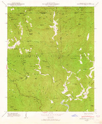
1946 Map of Hightower Bald
USGS Topo · Published 1965About this map
Tate City and the settlement of Persimmon sit within a high-elevation landscape where the Nantahala National Forest meets the Chattahoochee National Forest. The 1946 topography, examined by the Tennessee Valley Authority, captures the area when local education was still anchored by the Tate City Sch and Pleasant Hill Sch. The Appalachian Trail follows the ridge lines through Bly Gap and past Dicks Creek Gap, tracing the boundary between North Carolina and Georgia. The drainage patterns of the Tallulah River and Persimmon Creek reveal the isolation of these mountain communities, where roads often follow the narrow creek beds like Popcorn Creek and Hannah Branch. Notable landmarks such as King Chapel and family-named features like Montgomery Corner provide essential points of reference for genealogists tracing ancestral roots in Rabun and Towns counties.
Find a feature on this map
102 named features on this map. Tap any name to fly to it.
Don’t see what you’re looking for? This feature index may not catch every label — zoom into the map to look around manually.
Map Details
Editions of this 1946 Hightower Bald Map
4 editions found
Other maps of this area

1886 · Dahlonega
USGS Topo · 1:125,000

1886 · Walhalla
USGS Topo · 1:125,000

1891 · Cowee
USGS Topo · 1:125,000

1892 · Dahlonega
USGS Topo · 1:125,000

1892 · Walhalla
USGS Topo · 1:125,000

1896 · Walhalla
USGS Topo · 1:125,000

1896 · Dahlonega
USGS Topo · 1:125,000

1897 · Cowee
USGS Topo · 1:125,000

1903 · Dahlonega
USGS Topo · 1:125,000

1907 · Cowee
USGS Topo · 1:125,000