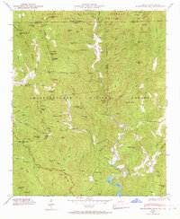
1946 Map of Hightower Bald
USGS Topo · Published 1968About this map
Tate City sits at the heart of this mountain landscape, positioned along the upper Tallulah River near the intersection of several county lines. This mid-century survey illustrates the rural infrastructure of the North Georgia and North Carolina borderlands, where the Blue Ridge Tenn Valley Divide separates the watersheds. Local life is anchored by institutions like the Tate City School and Pleasant Hill School, while the spiritual landscape is marked by King Chapel and Plumorchard Church.
Find a feature on this map
98 named features on this map. Tap any name to fly to it.
Don’t see what you’re looking for? This feature index may not catch every label — zoom into the map to look around manually.
Map Details
Editions of this 1946 Hightower Bald Map
4 editions found
Other maps of this area

1886 · Dahlonega
USGS Topo · 1:125,000

1886 · Walhalla
USGS Topo · 1:125,000

1891 · Cowee
USGS Topo · 1:125,000

1892 · Dahlonega
USGS Topo · 1:125,000

1892 · Walhalla
USGS Topo · 1:125,000

1896 · Walhalla
USGS Topo · 1:125,000

1896 · Dahlonega
USGS Topo · 1:125,000

1897 · Cowee
USGS Topo · 1:125,000

1903 · Dahlonega
USGS Topo · 1:125,000

1907 · Cowee
USGS Topo · 1:125,000