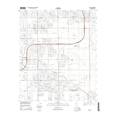
2014 Map of Higley
USGS Topo · Published 2014About this map
Higley and the surrounding desert southeast of Mesa reflect a landscape in rapid transition during this 2014 survey. The map details the dense residential expansion from Gilbert and the burgeoning community of Queen Creek, where modern suburban street grids contrast with the historical water management infrastructure of the Roosevelt Canal and Queen Creek Canal. In the eastern half of the sheet, the expansive grounds of the Phoenix-Mesa Gateway Airport occupy a significant footprint, serving as a regional hub for the growing East Valley. Traces of the area's agricultural past remain visible through the irrigation channels and the small settlement of Germann, even as the corridor along Queen Creek transforms into a developed municipality. This survey provides a precise look at the suburbanization of the Salt River Valley before the final infill of these formerly rural spaces.
Find a feature on this map
135 named features on this map. Tap any name to fly to it.
Don’t see what you’re looking for? This feature index may not catch every label — zoom into the map to look around manually.
Map Details
Editions of this 2014 Higley Map
This is the sole edition of this map. No revisions or reprints were ever made.
Other maps of this area

1904 · Desert Well
USGS Topo · 1:62,500

1906 · Desert Well
USGS Topo · 1:62,500

1907 · Sacaton
USGS Topo · 1:62,500

1913 · Mesa
USGS Topo · 1:62,500

1914 · Gila Butte
USGS Topo · 1:62,500

1915 · Mesa
USGS Topo · 1:62,500

1917 · Gila Butte
USGS Topo · 1:62,500

1952 · Chandler
USGS Topo · 1:24,000
1952 · Mesa
USGS Topo · 1:24,000

1952 · Gila Butte
USGS Topo · 1:24,000