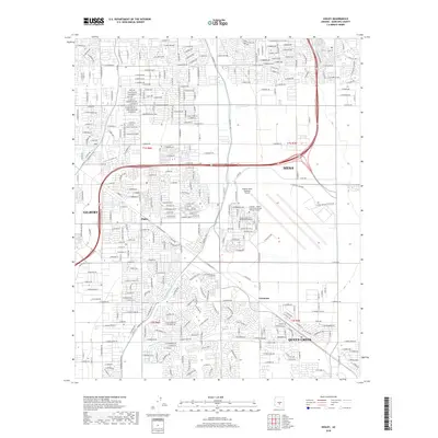
2018 Map of Higley
USGS Topo · Published 2018About this map
Higley and Queen Creek are central to this landscape in the eastern reaches of the Salt River Valley, where rapidly expanding residential neighborhoods meet institutional hubs. The map detail highlights a unique cluster of educational and aviation infrastructure, specifically the Arizona State Univ Polytechnic Campus and the adjacent Chandler - Gilbert Community College Williams Campus. These institutions are situated on the grounds of the former Williams Air Force Base, now serving the region as the Phoenix-Mesa Gateway Airport. Water management remains a visible priority in the desert environment, evidenced by the Roosevelt Canal and Queen Cr Canal cutting through the grid. The development patterns here illustrate the late 20th and early 21st-century growth of Mesa and Gilbert, transforming what was once primarily agricultural land into a densely networked suburban corridor.
Find a feature on this map
24 named features on this map. Tap any name to fly to it.
Don’t see what you’re looking for? This feature index may not catch every label — zoom into the map to look around manually.
Map Details
Editions of this 2018 Higley Map
This is the sole edition of this map. No revisions or reprints were ever made.
Other maps of this area

1904 · Desert Well
USGS Topo · 1:62,500

1906 · Desert Well
USGS Topo · 1:62,500

1907 · Sacaton
USGS Topo · 1:62,500

1913 · Mesa
USGS Topo · 1:62,500

1914 · Gila Butte
USGS Topo · 1:62,500

1915 · Mesa
USGS Topo · 1:62,500

1917 · Gila Butte
USGS Topo · 1:62,500

1952 · Chandler
USGS Topo · 1:24,000
1952 · Mesa
USGS Topo · 1:24,000

1952 · Gila Butte
USGS Topo · 1:24,000