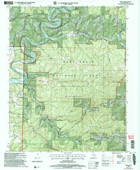
2004 Map of Hilda
USGS Topo · Published 2006About this map
The small settlement of Hilda and the Chapel of the Ozarks anchor this landscape within the Mark Twain National Forest. The area is defined by the rugged drainage network of the White River basin, where Beaver Creek and Long Creek feed into the northern reaches of Bull Shoals Lake. This 2004 revision reveals a preserved wilderness character, specifically within the Hercules Glades Wilderness, where high points like Lower Pilot Knob and Upper Pilot Knob rise above the surrounding hollows. Family history is etched into the terrain through numerous small burial grounds, including the Lone Pilgrim Cem, Johnson Cem, and Roberts Cem. The map traces a system of upland ridges and steep hollows such as Hoot Owl Hollow and Wild Cat Hollow, illustrating the deeply dissected topography of the Ozark plateau before it meets the inundated valleys of the lake.
Find a feature on this map
59 named features on this map. Tap any name to fly to it.
Don’t see what you’re looking for? This feature index may not catch every label — zoom into the map to look around manually.
Map Details
Editions of this 2004 Hilda Map
This is the sole edition of this map. No revisions or reprints were ever made.
Other maps of this area

1907 · Forsyth
USGS Topo · 1:125,000

1937 · Bradleyville
USGS Topo · 1:48,000

1943 · Protem
USGS Topo · 1:62,500

1943 · Bradleyville
USGS Topo · 1:62,500

1945 · Harrison
USGS Topo · 1:250,000

1945 · Bradleyville
USGS Topo · 1:62,500

1949 · Harrison
USGS Topo · 1:250,000

1954 · Harrison
USGS Topo · 1:250,000

1955 · Garrison
USGS Topo · 1:24,000
1956 · Mincy
USGS Topo · 1:24,000