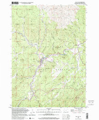
1998 Map of Hill City
USGS Topo · Published 2001About this map
Hill City sits at the heart of this landscape, surrounded by the high peaks and timberlands of the Black Hills National Forest. The map documents a rugged mining economy that has shaped the area for generations, evidenced by the high concentration of extraction sites tucked into narrow gulches. From the Gold Mountain Mine in the northwest to the Dolcode Mine and Summit Mine in the east, these labels trace a history of prospecting along tributaries like Battle Creek and Spring Creek. Settlement patterns follow the winding path of the creeks and rail lines, with small clusters like Kennedyville and infrastructure like the Ranger Station marking local activity. The presence of specialized features such as Tailings Ponds south of the city center provides a clear indication of the industrial scale of local mineral processing throughout the late 20th century.
Find a feature on this map
69 named features on this map. Tap any name to fly to it.
Don’t see what you’re looking for? This feature index may not catch every label — zoom into the map to look around manually.
Map Details
Editions of this 1998 Hill City Map
This is the sole edition of this map. No revisions or reprints were ever made.
Other maps of this area

1893 · Rapid
USGS Topo · 1:125,000

1894 · Deadwood
USGS Topo · 1:125,000

1894 · Hermosa
USGS Topo · 1:125,000

1896 · Harney Peak
USGS Topo · 1:125,000

1898 · Rapid
USGS Topo · 1:125,000

1901 · Hermosa
USGS Topo · 1:125,000

1901 · Harney Peak
USGS Topo · 1:125,000

1901 · Deadwood
USGS Topo · 1:125,000

1903 · Rapid
USGS Topo · 1:125,000

1916 · Deadwood
USGS Topo · 1:125,000