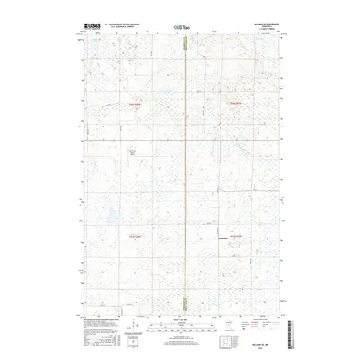
2016 Map of Hillman SE
USGS Topo · Published 2016About this map
Johnsdale sits at the eastern edge of this landscape where the Morrison Co and Mille Lacs Co lines meet. The terrain is defined by an intricate network of wetlands and small watercourses, including the Rum River in the northeast and the winding path of Hillman Cr further south. This 2016 survey illustrates the low-lying, saturated nature of the region, where roads like Co Rd 25 and 350th St must navigate around numerous unnamed ponds and marshy depressions. A notable point of private infrastructure is the North Star Ranch Airport, located in the western portion of the map. The drainage patterns are further highlighted by the N Fork Bradbury Brook and Skunk Lake, showing a landscape where water and soil are closely bound, dictating the sparse settlement and agricultural patterns of the early 21st century.
Find a feature on this map
19 named features on this map. Tap any name to fly to it.
Don’t see what you’re looking for? This feature index may not catch every label — zoom into the map to look around manually.
Map Details
Editions of this 2016 Hillman SE Map
This is the sole edition of this map. No revisions or reprints were ever made.
Other maps of this area

1953 · Duluth
USGS Topo · 1:250,000

1953 · Stillwater
USGS Topo · 1:250,000

1955 · Stillwater
USGS Topo · 1:250,000

1958 · Stillwater
USGS Topo · 1:250,000

1958 · Duluth
USGS Topo · 1:250,000

1965 · Stillwater
USGS Topo · 1:250,000

1968 · Onamia NW
USGS Topo · 1:24,000

1968 · Ramey NE
USGS Topo · 1:24,000

1968 · Onamia
USGS Topo · 1:24,000
1968 · Platte Lake
USGS Topo · 1:24,000