
1967 Map of Hills NE
USGS Topo · Published 1968About this map
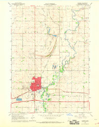
Springwater and Mound townships dominate the northern reaches of this Rock County landscape, which transitions into Beaver Creek and Luverne to the south. The terrain is defined by a dense network of section lines and farmstead placements typical of the Midwest's rural grid. In the lower portion of the map, the Chicago and North Western railroad cuts a diagonal path across the prairie, following the general course of Little Beaver Creek.
Find a feature on this map
9 named features on this map. Tap any name to fly to it.
Don’t see what you’re looking for? This feature index may not catch every label — zoom into the map to look around manually.
Map Details
Editions of this 1967 Hills NE Map
This is the sole edition of this map. No revisions or reprints were ever made.
Other maps of this area

1955 · Sioux Falls
USGS Topo · 1:250,000

1958 · Sioux Falls
USGS Topo · 1:250,000

1967 · Valley Springs
USGS Topo · 1:24,000

1967 · Edgerton South
USGS Topo · 1:24,000

1967 · Garretson East
USGS Topo · 1:24,000

1967 · Hills
USGS Topo · 1:24,000

1967 · Jasper SE
USGS Topo · 1:24,000

1967 · Jasper
USGS Topo · 1:24,000

1967 · Ash Creek
USGS Topo · 1:24,000
1967 · Luverne
USGS Topo · 1:24,000
Featured Places
- Springwater Township, MN
- Mound Township, MN
- Beaver Creek Township, MN
- Luverne Township, MN
- Rock County, MN