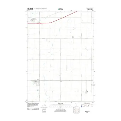
2010 Map of Hills
USGS Topo · Published 2010About this map
The farming community of Hills and the nearby village of Steen anchor this prairie landscape in the southwestern corner of Minnesota during the early 21st century. The map reveals a strictly organized section-line road grid, including County Hwy-53 and County Hwy-11, which service the agricultural homesteads between Mud Creek and Ash Creek. Local heritage is deeply embedded in the land through numerous small burial grounds and spiritual centers, such as the Dutch Reform Church and Bethlehem Cemetery. The presence of the Beaver Creek Post Office, Hills Post Office, and Steen Post Office indicates the continued importance of these small rural hubs. This area, just north of the Iowa border, showcases a terrain defined by subtle drainage patterns and the steady infrastructure of the American Midwest.
Find a feature on this map
32 named features on this map. Tap any name to fly to it.
Don’t see what you’re looking for? This feature index may not catch every label — zoom into the map to look around manually.
Map Details
Editions of this 2010 Hills Map
This is the sole edition of this map. No revisions or reprints were ever made.
Other maps of this area

1955 · Sioux Falls
USGS Topo · 1:250,000

1958 · Sioux Falls
USGS Topo · 1:250,000

1967 · Valley Springs
USGS Topo · 1:24,000

1967 · Garretson East
USGS Topo · 1:24,000

1967 · Hills
USGS Topo · 1:24,000

1967 · Hills NE
USGS Topo · 1:24,000

1967 · Ash Creek
USGS Topo · 1:24,000
1967 · Luverne
USGS Topo · 1:24,000

1971 · Lester
USGS Topo · 1:24,000
1971 · Larchwood
USGS Topo · 1:24,000