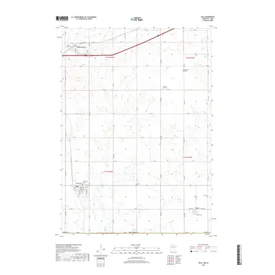
2019 Map of Hills
USGS Topo · Published 2019About this map
Hills and Steen are central settlements in this Rock County landscape, reflecting the agricultural and social centers that define the southwest corner of Minnesota. The region is part of the Coteau des Prairies, an upland plateau that influences the drainage patterns of local waterways like Beaver Creek, Mud Creek, and Ash Creek. The distribution of local landmarks suggests a community deeply rooted in its heritage, with several burial sites including Flowerfield Cem, Trinity Cem, and Pleasant View Cem situated across the townships.
Find a feature on this map
40 named features on this map. Tap any name to fly to it.
Don’t see what you’re looking for? This feature index may not catch every label — zoom into the map to look around manually.
Map Details
Editions of this 2019 Hills Map
This is the sole edition of this map. No revisions or reprints were ever made.
Other maps of this area

1955 · Sioux Falls
USGS Topo · 1:250,000

1958 · Sioux Falls
USGS Topo · 1:250,000

1967 · Valley Springs
USGS Topo · 1:24,000

1967 · Garretson East
USGS Topo · 1:24,000

1967 · Hills
USGS Topo · 1:24,000

1967 · Hills NE
USGS Topo · 1:24,000

1967 · Ash Creek
USGS Topo · 1:24,000
1967 · Luverne
USGS Topo · 1:24,000

1971 · Lester
USGS Topo · 1:24,000
1971 · Larchwood
USGS Topo · 1:24,000