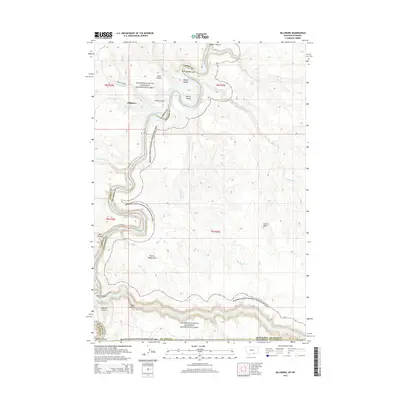
2014 Map of Hillsboro
USGS Topo · Published 2014About this map
Hillsboro and the surrounding borderlands of Montana and Wyoming are defined by the dramatic incision of the Bighorn Canyon National Recreation Area. The landscape is a complex network of deep drainages and named formations, where Bighorn Lake winds through steep walls between Barrys Island and Booz Canyon. The terrain reflects a raw geological character, with evocative place names such as Devils Playground, Garvin Basin, and the Natural Corrals marking the high ground above the water. Transport in this isolated area is limited to rugged routes like Barry's Landing Rd, which provides access to the canyon rim. The map also traces the winding course of significant tributaries, including Porcupine Cr, Bobcat Cr, and Twentymile Cr, which have carved their own paths toward the central Bighorn system.
Find a feature on this map
25 named features on this map. Tap any name to fly to it.
Don’t see what you’re looking for? This feature index may not catch every label — zoom into the map to look around manually.
Map Details
Editions of this 2014 Hillsboro Map
This is the sole edition of this map. No revisions or reprints were ever made.
Other maps of this area

1954 · Billings
USGS Topo · 1:250,000

1955 · Cody
USGS Topo · 1:250,000

1957 · Billings
USGS Topo · 1:250,000

1958 · Billings
USGS Topo · 1:250,000

1958 · Cody
USGS Topo · 1:250,000

1962 · Cody
USGS Topo · 1:250,000

1964 · Two Point
USGS Topo · 1:24,000
1964 · Simmons Canyon
USGS Topo · 1:24,000
1964 · Little Finger Ridge
USGS Topo · 1:24,000
1964 · Dead Indian Hill
USGS Topo · 1:24,000