
1964 Map of Two Point
USGS Topo · Published 1966About this map
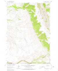
Garvin Basin dominates this mid-1960s survey along the rugged border of Montana and Wyoming. The landscape is defined by the sharp verticality of Big Bull Elk Ridge and Big Bull Elk Canyon, where the topography drops dramatically toward the bottomlands. To the south, the Crow Indian Reservation Boundary marks a significant administrative line across the drainage of Trout Creek and Willow Creek. This map captures a largely undeveloped wilderness navigated primarily by a network of Jeep Trails, highlighting the remote nature of Two Point and the surrounding high country. Water sources like Crystal Cave Spring and Gyp Creek appear as critical landmarks in an otherwise arid and deeply eroded terrain.
Find a feature on this map
17 named features on this map. Tap any name to fly to it.
Don’t see what you’re looking for? This feature index may not catch every label — zoom into the map to look around manually.
Map Details
Editions of this 1964 Two Point Map
2 editions found
Other maps of this area

1894 · St. Xavier
USGS Topo · 1:125,000

1898 · Bald Mountain
USGS Topo · 1:125,000

1901 · St. Xavier
USGS Topo · 1:125,000

1901 · Bald Mountain
USGS Topo · 1:125,000

1954 · Billings
USGS Topo · 1:250,000

1954 · Hardin
USGS Topo · 1:250,000

1955 · Cody
USGS Topo · 1:250,000

1955 · Sheridan
USGS Topo · 1:250,000

1957 · Hardin
USGS Topo · 1:250,000

1957 · Billings
USGS Topo · 1:250,000