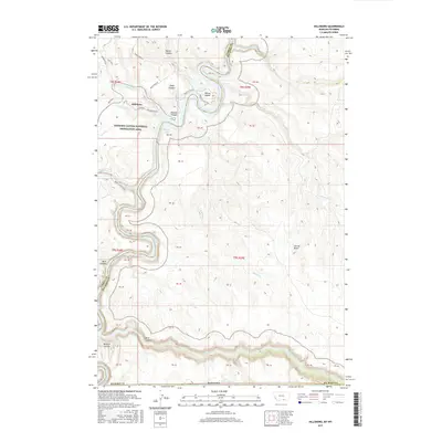
2017 Map of Hillsboro
USGS Topo · Published 2017About this map
Hillsboro sits at the northern end of this reach, where the Bighorn River carves deeply through the landscape of Carbon and Big Horn Counties. This survey documents the complex topography within the Bighorn Canyon National Recreation Area, showing a terrain defined by dramatic breaks like Devil Canyon and Booz Canyon. The hydrology is particularly prominent, featuring the winding course of Bighorn Lake and several seasonal drainages such as Porcupine Creek and Twentymile Creek. Notable landmarks like the Natural Corrals and Barrys Island are mapped alongside local access routes including Dryhead Road and Hillsboro Road. The map also captures the East Reservoir and the Garvin Basin, illustrating a high-desert environment managed for both conservation and recreation in the early twenty-first century.
Find a feature on this map
48 named features on this map. Tap any name to fly to it.
Don’t see what you’re looking for? This feature index may not catch every label — zoom into the map to look around manually.
Map Details
Editions of this 2017 Hillsboro Map
This is the sole edition of this map. No revisions or reprints were ever made.
Other maps of this area

1954 · Billings
USGS Topo · 1:250,000

1955 · Cody
USGS Topo · 1:250,000

1957 · Billings
USGS Topo · 1:250,000

1958 · Billings
USGS Topo · 1:250,000

1958 · Cody
USGS Topo · 1:250,000

1962 · Cody
USGS Topo · 1:250,000

1964 · Two Point
USGS Topo · 1:24,000
1964 · Simmons Canyon
USGS Topo · 1:24,000
1964 · Little Finger Ridge
USGS Topo · 1:24,000
1964 · Dead Indian Hill
USGS Topo · 1:24,000