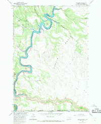
1964 Map of Hillsboro
USGS Topo · Published 1968About this map
Hillsboro stands as a focal point near the northern reaches of the Bighorn Canyon Yellowtail Reservoir in this mid-1960s survey. The landscape is defined by the dramatic winding path of the Bighorn River, which carves through deep canyons and creates prominent landforms like Barrys Island. This era captures the region shortly after the formation of the Bighorn Canyon National Recreation Area, showing a transition from traditional land use to a managed wilderness. Significant geological and archaeological interest is marked by Bighorn Caverns and Horse Thief Cave, alongside intriguing terrain features such as the Devils Playground and Natural Corrals. The map also delineates the Crow Indian Reservation Boundary and the state line between Montana and Wyoming, illustrating how political and cultural borders intersect with the complex topography of Garvin Basin.
Find a feature on this map
29 named features on this map. Tap any name to fly to it.
Don’t see what you’re looking for? This feature index may not catch every label — zoom into the map to look around manually.
Map Details
Editions of this 1964 Hillsboro Map
This is the sole edition of this map. No revisions or reprints were ever made.
Other maps of this area

1954 · Billings
USGS Topo · 1:250,000

1955 · Cody
USGS Topo · 1:250,000

1957 · Billings
USGS Topo · 1:250,000

1958 · Billings
USGS Topo · 1:250,000

1958 · Cody
USGS Topo · 1:250,000

1962 · Cody
USGS Topo · 1:250,000

1964 · Two Point
USGS Topo · 1:24,000
1964 · Simmons Canyon
USGS Topo · 1:24,000
1964 · Little Finger Ridge
USGS Topo · 1:24,000
1964 · Dead Indian Hill
USGS Topo · 1:24,000