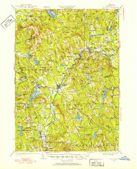
1926 Map of Hillsboro
USGS Topo · Published 1952About this map
The Birthplace of Franklin Pierce stands as a notable historical landmark near the Contoocook River, anchoring a landscape defined by 19th-century New England industrial and agricultural patterns. This survey shows the region as a network of interconnected villages including Hillsboro, Antrim, and Henniker, all linked by the Boston and Maine RR. The map illustrates the era's reliance on water power and early electrical infrastructure, evidenced by the Jackman Reservoir and various water bodies like Lake Massasecum and Gregg Lake.
Find a feature on this map
129 named features on this map. Tap any name to fly to it.
Don’t see what you’re looking for? This feature index may not catch every label — zoom into the map to look around manually.
Map Details
Editions of this 1926 Hillsboro Map
2 editions found
Other maps of this area

1898 · Monadnock
USGS Topo · 1:62,500

1900 · Peterboro
USGS Topo · 1:62,500

1902 · Sunapee
USGS Topo · 1:62,500

1905 · Sunapee
USGS Topo · 1:62,500

1906 · Milford
USGS Topo · 1:62,500

1907 · Sunapee
USGS Topo · 1:62,500

1926 · Hillsboro
USGS Topo · 1:62,500

1927 · Concord
USGS Topo · 1:62,500

1927 · Penacook
USGS Topo · 1:62,500

1928 · Mount Kearsarge
USGS Topo · 1:62,500