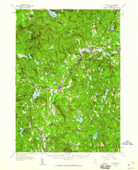
1957 Map of Hillsboro
USGS Topo · Published 1960About this map
The Contoocook River winds through this mid-century landscape, anchoring a series of mill towns and villages connected by the Boston and Maine railroad. Centers of industry and commerce like Hillsboro, Henniker, and Antrim are shown at a peak of post-war development, still closely tied to the water power and rail lines that defined their 19th-century growth. The map reveals a dense network of local institutions, including the uniquely named Donkey School and the Fox Research Forest, indicating the region's transition towards specialized agriculture and conservation.
Find a feature on this map
154 named features on this map. Tap any name to fly to it.
Don’t see what you’re looking for? This feature index may not catch every label — zoom into the map to look around manually.
Map Details
Editions of this 1957 Hillsboro Map
3 editions found
Other maps of this area

1898 · Monadnock
USGS Topo · 1:62,500

1900 · Peterboro
USGS Topo · 1:62,500

1902 · Sunapee
USGS Topo · 1:62,500

1905 · Sunapee
USGS Topo · 1:62,500

1906 · Milford
USGS Topo · 1:62,500

1907 · Sunapee
USGS Topo · 1:62,500

1926 · Hillsboro
USGS Topo · 1:62,500

1927 · Concord
USGS Topo · 1:62,500

1927 · Penacook
USGS Topo · 1:62,500

1928 · Mount Kearsarge
USGS Topo · 1:62,500