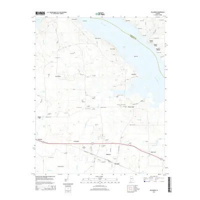
2014 Map of Hillsboro
USGS Topo · Published 2014About this map
Hillsboro and Reynolds serve as the primary hubs of activity along the southern edge of this Tennessee River valley landscape. The terrain is defined by the massive expanse of Wheeler Lake, which separates Lawrence and Limestone counties. To the north, the river is shaped by distinctive features such as Melton Bluff, Upper Bar, and Lower Bar. The map is particularly notable for its dense concentration of family and community burial grounds, illustrating a deeply rooted rural settlement pattern. Genealogists and local historians can trace legacy sites like Shackelford Cem, Swoope Cem, and Newman Cem scattered among smaller crossroads communities like Jerusalem and Flower Hill. The landscape transitions from the river flats near Mason Hollow and Egypt Bluff into the agricultural plains and marshy lowlands surrounding Harty Pond and Goose Pond.
Find a feature on this map
113 named features on this map. Tap any name to fly to it.
Don’t see what you’re looking for? This feature index may not catch every label — zoom into the map to look around manually.
Map Details
Editions of this 2014 Hillsboro Map
This is the sole edition of this map. No revisions or reprints were ever made.
Other maps of this area

1914 · Rogersville
USGS Topo · 1:48,000

1916 · Rogersville
USGS Topo · 1:62,500

1936 · Caddo
USGS Topo · 1:24,000

1936 · Thorntontown
USGS Topo · 1:24,000

1936 · Stewart Cross Roads
USGS Topo · 1:24,000

1936 · Courtland
USGS Topo · 1:24,000

1936 · Ripley
USGS Topo · 1:24,000

1936 · Trinity
USGS Topo · 1:24,000

1936 · Hillsboro
USGS Topo · 1:24,000

1936 · Cairo
USGS Topo · 1:24,000