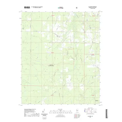
2021 Map of Hillsboro
USGS Topo · Published 2021About this map
The Bienville National Forest dominates this Scott County landscape, where the settlement of Clifton serves as a central point for a network of local roads including Clifton Rd and Harrell Rd. The area is defined by a dense hydrologic system, with the Strong River and Little River flowing through the territory alongside numerous creeks and bogues such as Shockaloo Cr, Sugar Bogue, and the uniquely named Tallahogue. For those exploring the wooded terrain, the Shockaloe Horse Trail winds extensively through the forest. Genealogy interest is anchored by several local burial sites, including the Old Duncan Cem and Lone Pilgrim Cem, while the Lebanon Church Cem sits near the northern boundary. The rural character is further detailed through family-named thoroughfares like Hattie Lyles Rd and Aycock Rd, reflecting the long-standing land divisions of the region.
Find a feature on this map
57 named features on this map. Tap any name to fly to it.
Don’t see what you’re looking for? This feature index may not catch every label — zoom into the map to look around manually.
Map Details
Editions of this 2021 Hillsboro Map
This is the sole edition of this map. No revisions or reprints were ever made.
Other maps of this area

1921 · Forest
USGS Topo · 1:48,000

1922 · Forest
USGS Topo · 1:62,500

1922 · Morton
USGS Topo · 1:48,000

1924 · Morton
USGS Topo · 1:62,500

1950 · Forest
USGS Topo · 1:62,500

1951 · Morton
USGS Topo · 1:62,500

1952 · Forest
USGS Topo · 1:62,500

1953 · Meridian
USGS Topo · 1:250,000

1957 · Meridian
USGS Topo · 1:250,000

1961 · Carthage
USGS Topo · 1:62,500