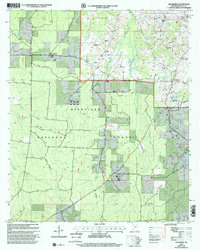
2000 Map of Hillsboro
USGS Topo · Published 2002About this map
The Bienville National Forest dominates the landscape of this Scott County area at the turn of the millennium. The settlement of Hillsboro serves as the local hub, while the surrounding countryside is dotted with long-standing community markers like the Old Duncan Cem and Macedonia Ch. This revision, updated by the U.S. Forest Service, reflects a landscape where managed timberlands and recreational infrastructure coexist with rural agriculture and traditional family landmarks.
Find a feature on this map
20 named features on this map. Tap any name to fly to it.
Don’t see what you’re looking for? This feature index may not catch every label — zoom into the map to look around manually.
Map Details
Editions of this 2000 Hillsboro Map
This is the sole edition of this map. No revisions or reprints were ever made.
Other maps of this area

1921 · Forest
USGS Topo · 1:48,000

1922 · Forest
USGS Topo · 1:62,500

1922 · Morton
USGS Topo · 1:48,000

1924 · Morton
USGS Topo · 1:62,500

1950 · Forest
USGS Topo · 1:62,500

1951 · Morton
USGS Topo · 1:62,500

1952 · Forest
USGS Topo · 1:62,500

1953 · Meridian
USGS Topo · 1:250,000

1957 · Meridian
USGS Topo · 1:250,000

1961 · Carthage
USGS Topo · 1:62,500