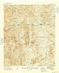
1940 Map of Hillsboro
USGS Topo · Published 1949About this map
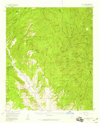
Hillsboro and Kingston serve as the primary hubs in this high-desert mining landscape, where the rugged terrain of the Gila National Forest meets the scattered ranching operations of Sierra County. The 1930s survey data reveals a territory defined by hard-rock extraction and isolated homesteads, with the Gray Eagle Mine and Silvertail Mine marking the era's industrial activity. Dozens of deep canyons, such as Percha Creek and Tierra Blanca Creek, carve through the landscape, providing essential water sources for cattle operations like the JP Nunn Ranch and the O Bar O. Notable landmarks such as Schoolhouse Mtn and Empire Peak rise above the gulches, while the presence of the Kingston Ranger Sta indicates the early administrative management of the forest's timber and grazing resources.
Find a feature on this map
87 named features on this map. Tap any name to fly to it.
Don’t see what you’re looking for? This feature index may not catch every label — zoom into the map to look around manually.
Map Details
Editions of this 1940 Hillsboro Map
2 editions found
Other maps of this area
1935 · Hillsboro
USGS Topo · 1:48,000
1940 · Hillsboro
USGS Topo · 1:62,500

1954 · Tularosa
USGS Topo · 1:250,000

1955 · Las Cruces
USGS Topo · 1:250,000
1956 · Dwyer
USGS Topo · 1:62,500
1956 · San Lorenzo
USGS Topo · 1:62,500

1958 · Las Cruces
USGS Topo · 1:250,000

1958 · Tularosa
USGS Topo · 1:250,000

1961 · Skute Stone Arroyo
USGS Topo · 1:24,000
1961 · Saladone Tank
USGS Topo · 1:24,000