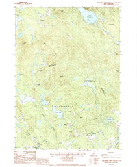
1987 Map of Hillsboro Upper Village
USGS Topo · Published 1987About this map
Hillsboro Upper Village and the high ground of southern Merrimack County define this late 20th-century landscape. The map highlights the traditional settlement patterns of central New Hampshire, with Hillsboro Center and Bradford Center serving as historic focal points amidst a terrain of prominent elevations like Rowes Hill and Mt Misery. The water network is particularly dense here, featuring the expansive Lake Massasecum in the north and the winding Contoocook River in the southeast corner.
Find a feature on this map
42 named features on this map. Tap any name to fly to it.
Don’t see what you’re looking for? This feature index may not catch every label — zoom into the map to look around manually.
Map Details
Editions of this 1987 Hillsboro Upper Village Map
This is the sole edition of this map. No revisions or reprints were ever made.
Other maps of this area

1902 · Sunapee
USGS Topo · 1:62,500

1905 · Sunapee
USGS Topo · 1:62,500

1907 · Sunapee
USGS Topo · 1:62,500

1926 · Hillsboro
USGS Topo · 1:62,500

1928 · Mount Kearsarge
USGS Topo · 1:62,500

1929 · Hillsboro
USGS Topo · 1:62,500

1930 · Lovewell Mountain
USGS Topo · 1:62,500

1931 · Mount Kearsarge
USGS Topo · 1:62,500

1942 · Lovewell Mountain
USGS Topo · 1:62,500

1949 · Portland
USGS Topo · 1:250,000