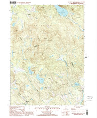
1998 Map of Hillsboro Upper Village
USGS Topo · Published 2001About this map
Hillsboro Center and Hillsboro Upper Village anchor this corner of New England, where the landscape is defined by its extensive protected woodlands and a complex network of brooks and ponds. Large tracts such as the Low State Forest, Fox State Forest, and the Farrar Marsh State Wildlife Management Area preserve the area's timbered character between the municipal boundaries of Bradford, Warner, and Henniker. Water defines the local geography, from the broad Lake Massasecum in the north to the Contoocook River in the southeast.
Find a feature on this map
41 named features on this map. Tap any name to fly to it.
Don’t see what you’re looking for? This feature index may not catch every label — zoom into the map to look around manually.
Map Details
Editions of this 1998 Hillsboro Upper Village Map
This is the sole edition of this map. No revisions or reprints were ever made.
Other maps of this area

1902 · Sunapee
USGS Topo · 1:62,500

1905 · Sunapee
USGS Topo · 1:62,500

1907 · Sunapee
USGS Topo · 1:62,500

1926 · Hillsboro
USGS Topo · 1:62,500

1928 · Mount Kearsarge
USGS Topo · 1:62,500

1929 · Hillsboro
USGS Topo · 1:62,500

1930 · Lovewell Mountain
USGS Topo · 1:62,500

1931 · Mount Kearsarge
USGS Topo · 1:62,500

1942 · Lovewell Mountain
USGS Topo · 1:62,500

1949 · Portland
USGS Topo · 1:250,000