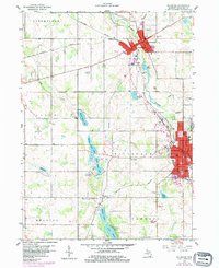
1959 Map of Hillsdale
USGS Topo · Published 1984About this map
Hillsdale College stands as a prominent landmark in this 1959 portrait of the county seat and neighboring Jonesville. The landscape is defined by the New York Central Railroad corridor, which connects these industrial and educational centers while threading through the diverse terrain of Hillsdale and Fayette townships. The presence of specialized institutions like the Manor Foundation Sch and multiple healthcare facilities, including the municipal Hospital and Maple Lawn Hospital, underscores the area's role as a regional service hub.
Find a feature on this map
47 named features on this map. Tap any name to fly to it.
Don’t see what you’re looking for? This feature index may not catch every label — zoom into the map to look around manually.
Map Details
Editions of this 1959 Hillsdale Map
2 editions found
Other maps of this area

1948 · Spring Arbor
USGS Topo · 1:62,500

1948 · Homer
USGS Topo · 1:62,500

1949 · Homer
USGS Topo · 1:62,500

1949 · Spring Arbor
USGS Topo · 1:62,500

1953 · Fort Wayne
USGS Topo · 1:250,000

1956 · Fort Wayne
USGS Topo · 1:250,000

1958 · Grand Rapids
USGS Topo · 1:250,000

1959 · Hillsdale
USGS Topo · 1:24,000

1959 · Reading
USGS Topo · 1:24,000

1959 · North Adams
USGS Topo · 1:24,000