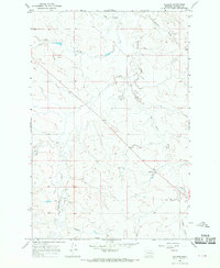
1965 Map of Hillside
USGS Topo · Published 1969About this map
Hillside sits at the heart of this Montana landscape, a small settlement defined by its position among the branching drainages of Garfield County. Surveyed in the mid-1960s, the area is characterized by an intricate network of coulees and creeks that dictated the movement of early ranchers and travelers. The terrain is carved by Thompson Creek, which runs north-to-south, and is joined by several seasonal waterways including Todd Coulee and Artz Coulee. These features represent the classic topography of the Missouri River Breaks region, where water sources were the primary anchor for homesteading and grazing. The map meticulously documents several wells and small reservoirs, such as those along Red Butte Creek, reflecting the essential water management practices of the era. The presence of Bickels Coulee and Douglas Coulee in the southern reaches further illustrates the corrugated nature of this prairie country.
Find a feature on this map
10 named features on this map. Tap any name to fly to it.
Don’t see what you’re looking for? This feature index may not catch every label — zoom into the map to look around manually.
Map Details
Editions of this 1965 Hillside Map
This is the sole edition of this map. No revisions or reprints were ever made.
Other maps of this area

1954 · Jordan
USGS Topo · 1:250,000

1954 · Forsyth
USGS Topo · 1:250,000

1956 · Jordan
USGS Topo · 1:250,000

1957 · Forsyth
USGS Topo · 1:250,000

1958 · Jordan
USGS Topo · 1:250,000

1958 · Forsyth
USGS Topo · 1:250,000

1964 · Jordan
USGS Topo · 1:250,000

1965 · Needle Butte
USGS Topo · 1:24,000

1965 · Cohagen
USGS Topo · 1:24,000

1965 · Clear Water Reservoir
USGS Topo · 1:24,000