
1965 Map of Clear Water Reservoir
USGS Topo · Published 1968About this map
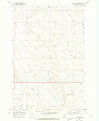
The Garfield Co Rosebud Co boundary line bisects this mid-1960s landscape, which is defined by an intricate network of intermittent drainage and upland water sources. The map focuses on the rolling topography surrounding Thompson Creek and the headwaters of the North Sunday Creek. A central point of local significance is the North Sunday Sch, situated near the confluence of the West Fork North Sunday Creek. Settlement is sparse, represented by localized points like Thompson and Mabdin, suggesting a community built around ranching and limited resource extraction. The presence of Pride Springs and several wells indicates the critical importance of water management in this environment, anchored by the Clear Water Reservoir in the northwest. This survey provides a precise record of rural Montana infrastructure before modern developments, highlighting small-scale landmarks like a local Sandpit.
Find a feature on this map
15 named features on this map. Tap any name to fly to it.
Don’t see what you’re looking for? This feature index may not catch every label — zoom into the map to look around manually.
Map Details
Editions of this 1965 Clear Water Reservoir Map
This is the sole edition of this map. No revisions or reprints were ever made.
Other maps of this area

1954 · Forsyth
USGS Topo · 1:250,000

1957 · Forsyth
USGS Topo · 1:250,000

1958 · Forsyth
USGS Topo · 1:250,000

1965 · Needle Butte
USGS Topo · 1:24,000
1965 · Coleman Coulee
USGS Topo · 1:24,000
1965 · Christenson Reservoir
USGS Topo · 1:24,000
1965 · Hillside
USGS Topo · 1:24,000
1965 · Red Buttes
USGS Topo · 1:24,000

1969 · Van Burton Creek
USGS Topo · 1:24,000
1969 · Alkali Creek
USGS Topo · 1:24,000