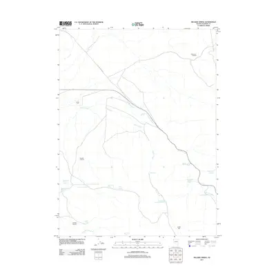
2011 Map of Hillside Spring
USGS Topo · Published 2011About this map
Hoover Ranch stands as a primary point of human activity in this arid basin of Washoe County, characterized by a complex network of ephemeral washes and essential water developments. The landscape is defined by the drainage of Duck Flat Wash and Willow Creek, which support a series of livestock-oriented water sources. A sophisticated water management system is evident through the numbering of several high-desert reservoirs, including Buffalo Hills Reservoir Number 10, Buffalo Hills Reservoir Number 9, and Buffalo Hills Reservoir Number 6. The terrain is deeply inscribed with name-heavy canyons such as Old Camp Canyon and Coyote Canyon, while localized springs like Hillside Spring and Smokey Spring provide rare points of permanent water. Navigation through this remote range relies on routes like Old Camp Canyon Rd, which cuts across the flats near Disabel Reservoir.
Find a feature on this map
24 named features on this map. Tap any name to fly to it.
Don’t see what you’re looking for? This feature index may not catch every label — zoom into the map to look around manually.
Map Details
Editions of this 2011 Hillside Spring Map
This is the sole edition of this map. No revisions or reprints were ever made.
Other maps of this area

1886 · Granite Range
USGS Topo · 1:250,000

1889 · Long Valley
USGS Topo · 1:250,000

1894 · Granite Range
USGS Topo · 1:250,000

1954 · Vya
USGS Topo · 1:250,000

1955 · Lovelock
USGS Topo · 1:250,000

1958 · Vya
USGS Topo · 1:250,000

1959 · Lovelock
USGS Topo · 1:250,000

1962 · Vya
USGS Topo · 1:250,000
1980 · Fox Mountain
USGS Topo · 1:24,000
1980 · Lost Creek Pass
USGS Topo · 1:24,000