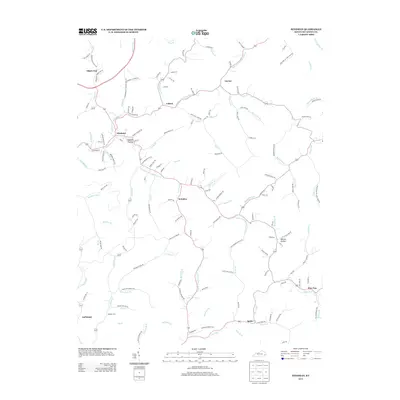
2013 Map of Hindman
USGS Topo · Published 2013About this map
Hindman serves as the focal point of this Knott County landscape, situated at the confluence of several prominent waterways including Troublesome Cr and Left Fork Troublesome Cr. The 2013 survey illustrates a region defined by intricate drainage systems and narrow hollows, where life and transit follow the winding paths of Mill Cr and Mile Fork. Named settlements like Brinkley, Leburn, and Spider are dispersed throughout the area, connected by a dense network of local roads such as Garner Rd and Owens Br. Genealogy researchers will find specific interest in Madden Cem and family-named landmarks such as Walnut Hollow and Tadpole Hollow. The topography reveals the characteristic Appalachian pattern of development, with homes and infrastructure concentrated in the valley floors of the Beechnut Fork and Irishman Cr watersheds.
Find a feature on this map
151 named features on this map. Tap any name to fly to it.
Don’t see what you’re looking for? This feature index may not catch every label — zoom into the map to look around manually.
Map Details
Editions of this 2013 Hindman Map
This is the sole edition of this map. No revisions or reprints were ever made.
Other maps of this area

1890 · Whitesburg
USGS Topo · 1:125,000

1891 · Hazard
USGS Topo · 1:125,000

1892 · Whitesburg
USGS Topo · 1:125,000

1912 · Hindman
USGS Topo · 1:48,000

1913 · Oven Fork
USGS Topo · 1:48,000

1914 · Troublesome
USGS Topo · 1:62,500

1915 · Hindman
USGS Topo · 1:62,500

1915 · Whitesburg
USGS Topo · 1:62,500

1916 · Cornettsville
USGS Topo · 1:62,500
1954 · Hindman
USGS Topo · 1:24,000