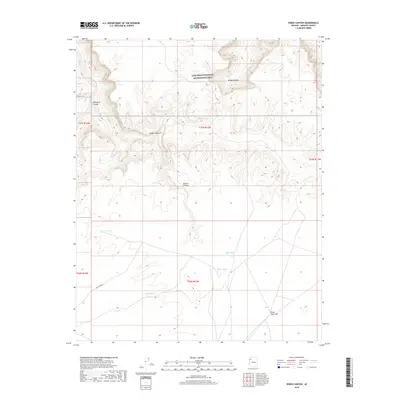
2018 Map of Hindu Canyon
USGS Topo · Published 2018About this map
Lake Mead National Recreation Area dominates the northern reaches of this landscape, where the high desert is carved into a series of profound geological formations. The eponymous Hindu Canyon sits at the center of a complex network of drainages, including Milkweed Canyon to the west and Spencer Canyon to the south. This terrain is defined by its water management features, critical in such an arid environment, with scattered catchments like Crozier Tank, Bender Tank, and Siple Tank providing vital points of reference across the sections. To the southeast, the land levels out into the broad Plain Tank Flat, accessed by the solitary Plain Tank Rd. The map illustrates a remote corner of Mohave County where the topography shifts from the sharp relief of Bridge Canyon to open flats, governed by the Public Land Survey System's township and range grid.
Find a feature on this map
16 named features on this map. Tap any name to fly to it.
Don’t see what you’re looking for? This feature index may not catch every label — zoom into the map to look around manually.
Map Details
Editions of this 2018 Hindu Canyon Map
This is the sole edition of this map. No revisions or reprints were ever made.
Other maps of this area

1886 · Diamond Creek
USGS Topo · 1:250,000

1892 · Diamond Creek
USGS Topo · 1:250,000

1948 · Williams
USGS Topo · 1:250,000

1954 · Williams
USGS Topo · 1:250,000

1956 · Williams
USGS Topo · 1:250,000

1960 · Williams
USGS Topo · 1:250,000

1961 · Williams
USGS Topo · 1:250,000
1967 · Milkweed Canyon SE
USGS Topo · 1:24,000

1967 · Milkweed Canyon SW
USGS Topo · 1:24,000

1967 · Peach Springs
USGS Topo · 1:24,000