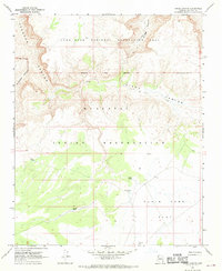
1967 Map of Hindu Canyon
USGS Topo · Published 1970About this map
The Hualapai Indian Reservation and the Lake Mead National Recreation Area meet in this 1967 survey of Mohave County. The landscape is defined by the massive drainage systems of Hindu Canyon, Spencer Canyon, and Milkweed Canyon, which cut through high plateaus. Within the reservation boundaries, the land management for ranching and transport is evident through a series of water catchments such as Crozier Tank, Siple Tank, and Bender Tank. The remote nature of the terrain at this time is further indicated by the presence of a Landing Strip and an extensive network of Jeep Trails and Pack Trails used to navigate the canyons. These trails provide evidence of the traditional and functional routes used before modern infrastructure, connecting high points like Plain Tank flat to the canyon floors.
Find a feature on this map
20 named features on this map. Tap any name to fly to it.
Don’t see what you’re looking for? This feature index may not catch every label — zoom into the map to look around manually.
Map Details
Editions of this 1967 Hindu Canyon Map
This is the sole edition of this map. No revisions or reprints were ever made.
Other maps of this area

1886 · Diamond Creek
USGS Topo · 1:250,000

1892 · Diamond Creek
USGS Topo · 1:250,000

1948 · Williams
USGS Topo · 1:250,000

1954 · Williams
USGS Topo · 1:250,000

1956 · Williams
USGS Topo · 1:250,000

1960 · Williams
USGS Topo · 1:250,000

1961 · Williams
USGS Topo · 1:250,000
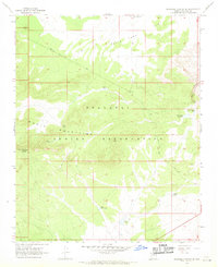
1967 · Milkweed Canyon SE
USGS Topo · 1:24,000

1967 · Milkweed Canyon SW
USGS Topo · 1:24,000

1967 · Peach Springs
USGS Topo · 1:24,000