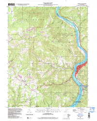
1998 Map of Hinton
USGS Topo · Published 2000About this map
Hinton serves as the focal point of this survey, situated at the confluence where the New River meets the Greenbrier River. The town's significance as a rail and administrative center is evidenced by the Courthouse, City Hall, and the extensive 3 tracks and 4 tracks rail infrastructure lining the riverbanks. To the south, the massive Bluestone Dam holds back the waters of Bluestone Lake, while the Bluestone State Wildlife Management Area and Bluestone State Park preserve the surrounding ridge lands.
Find a feature on this map
52 named features on this map. Tap any name to fly to it.
Don’t see what you’re looking for? This feature index may not catch every label — zoom into the map to look around manually.
Map Details
Editions of this 1998 Hinton Map
This is the sole edition of this map. No revisions or reprints were ever made.
Other maps of this area

1887 · Hinton
USGS Topo · 1:125,000

1891 · Raleigh
USGS Topo · 1:125,000

1892 · Hinton
USGS Topo · 1:125,000

1897 · Raleigh
USGS Topo · 1:125,000

1902 · Raleigh
USGS Topo · 1:125,000

1911 · Flattop
USGS Topo · 1:48,000

1911 · Beckley
USGS Topo · 1:48,000

1912 · Meadow Creek
USGS Topo · 1:48,000

1912 · Big Bend
USGS Topo · 1:62,500

1913 · Beckley
USGS Topo · 1:62,500