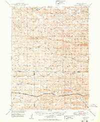
1950 Map of Hire
USGS Topo · Published 1950About this map
Hire and Weir serve as primary points of interest in this mid-century portrait of the Nebraska Sandhills where the borders of Cherry, Grant, and Hooker counties meet. The landscape is defined by the intricate hydrology of the Loup River system, specifically the convergence of the North Branch Middle Loup River, Middle Branch Middle Loup River, and South Branch Middle Loup River. The southern portion of the quadrangle is dominated by the industrial presence of the Chicago Burlington and Quincy railroad, which follows a path just north of Mullen. Rural educational life is anchored by locations such as Cox Sch in the north and School No 4 further south. Notable water features like Calf Creek and the curiously named Flowing Well suggest a reliance on steady water sources in this cattle-ranching country during the post-war era.
Find a feature on this map
16 named features on this map. Tap any name to fly to it.
Don’t see what you’re looking for? This feature index may not catch every label — zoom into the map to look around manually.
Map Details
Editions of this 1950 Hire Map
3 editions found

Other maps of this area

1947 · Dismal River Ranch
USGS Topo · 1:62,500

1948 · Carr Lake
USGS Topo · 1:62,500

1948 · Mullen
USGS Topo · 1:62,500

1948 · Whitman
USGS Topo · 1:62,500

1948 · Spring Valley
USGS Topo · 1:62,500

1949 · Dismal River Ranch
USGS Topo · 1:62,500

1949 · Big Falls
USGS Topo · 1:62,500

1949 · Steverson Lake
USGS Topo · 1:62,500

1950 · Spring Valley
USGS Topo · 1:62,500

1950 · Whitman
USGS Topo · 1:62,500