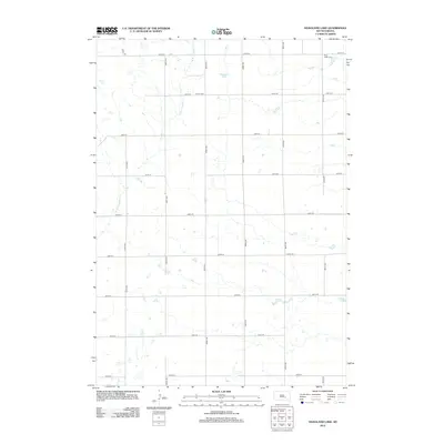
2012 Map of Hoagland Lake
USGS Topo · Published 2012About this map
Viola Valley Cem and Union Cem serve as quiet landmarks within this rural section of Jerauld County, where the landscape is defined by a grid of section-line roads and prairie wetlands. The township's water network is anchored by Hoagland Lake and the southeastern corner of Lake Fraser, while the meandering W Br Firesteel Cr drains the western territory. This 2012 survey illustrates a late-century agricultural pattern, where established cemetery sites remain the primary markers of historical community centers amidst the expansive farm plots. The precision of the road grid, from 379th Ave to 385th Ave, demonstrates the enduring influence of the Public Land Survey System on the South Dakota plains.
Find a feature on this map
20 named features on this map. Tap any name to fly to it.
Don’t see what you’re looking for? This feature index may not catch every label — zoom into the map to look around manually.
Map Details
Editions of this 2012 Hoagland Lake Map
This is the sole edition of this map. No revisions or reprints were ever made.
Other maps of this area

1898 · Huron
USGS Topo · 1:125,000

1899 · Mitchell
USGS Topo · 1:125,000

1942 · Crow Lake
USGS Topo · 1:62,500

1953 · Huron
USGS Topo · 1:250,000

1954 · Huron
USGS Topo · 1:250,000

1955 · Mitchell
USGS Topo · 1:250,000

1959 · Mitchell
USGS Topo · 1:250,000

1973 · Wessington Springs
USGS Topo · 1:24,000
1973 · Wessington Springs SW
USGS Topo · 1:24,000
1973 · Lane
USGS Topo · 1:24,000
Featured Places
- Viola Township, SD
- Pleasant Valley Township, SD
- Anina Township, SD
- Bristol Township, SD
- Aurora County, SD