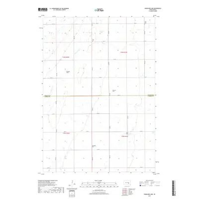
2017 Map of Hoagland Lake
USGS Topo · Published 2017About this map
Union Cem and Viola Valley Cem stand as significant genealogical landmarks in this section of rural South Dakota, located north of the Jerauld Co Aurora Co border. This 2017 survey illustrates a classic prairie landscape defined by drainage patterns and agricultural section lines. The hydrography is centered around Hoagland Lake and the winding course of W Br Firesteel Cr, which carves through the central terrain. Landform features like Hawkeye Valley and Piersons Draw indicate the natural basins and coulees of the region, while man-made water management is visible at Eraser Dam. The area is methodically gridded by local thoroughfares such as 382nd Ave and 234th St, reflecting the persistent township-and-range structure of the Great Plains.
Find a feature on this map
29 named features on this map. Tap any name to fly to it.
Don’t see what you’re looking for? This feature index may not catch every label — zoom into the map to look around manually.
Map Details
Editions of this 2017 Hoagland Lake Map
This is the sole edition of this map. No revisions or reprints were ever made.
Other maps of this area

1898 · Huron
USGS Topo · 1:125,000

1899 · Mitchell
USGS Topo · 1:125,000

1942 · Crow Lake
USGS Topo · 1:62,500

1953 · Huron
USGS Topo · 1:250,000

1954 · Huron
USGS Topo · 1:250,000

1955 · Mitchell
USGS Topo · 1:250,000

1959 · Mitchell
USGS Topo · 1:250,000

1973 · Wessington Springs
USGS Topo · 1:24,000
1973 · Wessington Springs SW
USGS Topo · 1:24,000
1973 · Lane
USGS Topo · 1:24,000
Featured Places
- Viola Township, SD
- Pleasant Valley Township, SD
- Anina Township, SD
- Bristol Township, SD
- Aurora County, SD